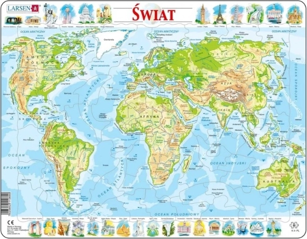
Larsen educational aid for a clear understanding of the world – a physical world map focused on relief, mountain ranges, lowlands, deserts, and bodies of water. Ideal for geography lessons at school as well as home practice.
The Larsen physical world map helps you understand Earth as it appears in terms of landscape and elevation. By highlighting natural features, it makes it easy to connect continents and oceans with the real conditions of individual regions.
Suitable as a school aid and for home learning – for school-age children and for adults who want to refresh their geography. It can be used for practicing map orientation as well as working with topics such as mountain ranges, rivers, and elevation zones.
Key features:
- Physical world map with a focus on relief and natural features
- Suitable for geography education and home practice
- Theme: world, continents, oceans and natural formations
- Variant labeled “PL” – most likely Polish labels (recommended to verify on the packaging)
Specifications
- Brand / Manufacturer
- Larsen
- Product name
- Świat – mapa fizyczna (physical world map)
- Model / Code
- LA-K4PL
- Internal designation
- 10690
- EAN
- 7023852110690
- Product type
- Educational map (physical world map)
- Theme
- World, continents and oceans, relief and natural features
- Map label language
- Most likely Polish (based on the “PL” marking) – recommended to verify on the packaging
- Suitable use
- Geography lessons, home practice, school aid
- Dimensions
- Not specified
- Material / Surface finish
- Not specified
- Format (poster / puzzle)
- Not specified
- Number of pieces (if a puzzle)
- Not specified
- Recommended age
- Not specified