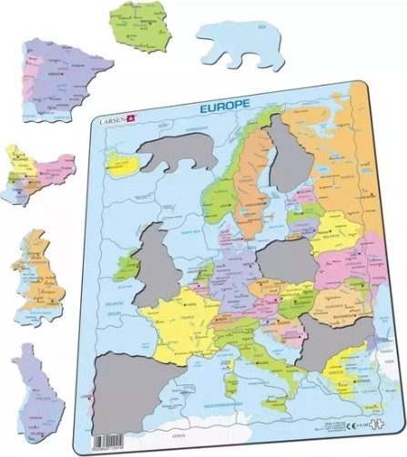
The Larsen political map of Europe is a clear educational aid for schoolchildren and home learning—helping you quickly get oriented in countries, borders, and Europe’s political division thanks to distinct color-coding of individual countries.
The Larsen map focuses on Europe’s political division, making it ideal for geography lessons, revision, and independent practice. You can use it at school and at home when working with country names and navigating the European region.
Main benefits:
- Political division of Europe—countries and borders clearly shown in one place
- Clear color differentiation of countries for easier memorization
- Suitable for school teaching, home preparation, and educational activities
- Practical for practice: country names, orientation by borders and regions
Specifications
- Brand
- Larsen
- Type
- Educational map of Europe (political division)
- Area
- Europe
- Product
- Europe – political map
- EAN
- 7023852112502
- Designation (code)
- LA-A8PL / 12502
- Language label
- “mapa polityczna” (Polish term for a political map)